


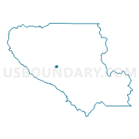
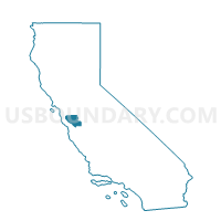
Voting District 10945, Santa Clara County, California
About
Outline

Summary
| Unique Area Identifier | 543710 |
| Name | Voting District 10945 |
| County | Santa Clara County |
| State | California |
| Area (square miles) | 0.86 |
| Land Area (square miles) | 0.86 |
| Water Area (square miles) | 0.00 |
| % of Land Area | 100.00 |
| % of Water Area | 0.00 |
| Latitude of the Internal Point | 37.21001240 |
| Longtitude of the Internal Point | -121.81138490 |
Maps

Graphs
Select a template below for downloading or customizing gragh for Voting District 10945, Santa Clara County, California


Neighbors
Neighoring Voting District (by Name) Neighboring Voting District on the Map
- Voting District 10810, Santa Clara County, CA
- Voting District 10825, Santa Clara County, CA
- Voting District 10960, Santa Clara County, CA
- Voting District 10965, Santa Clara County, CA
- Voting District 10995, Santa Clara County, CA
- Voting District 11000, Santa Clara County, CA
- Voting District 11115, Santa Clara County, CA
Top 10 Neighboring County Subdivision (by Population) Neighboring County Subdivision on the Map
Top 10 Neighboring Place (by Population) Neighboring Place on the Map
Top 10 Neighboring Elementary School District (by Population) Neighboring Elementary School District on the Map
Top 10 Neighboring Secondary School District (by Population) Neighboring Secondary School District on the Map
Top 10 Neighboring Unified School District (by Population) Neighboring Unified School District on the Map
Top 10 Neighboring State Legislative District Lower Chamber (by Population) Neighboring State Legislative District Lower Chamber on the Map
- Assembly District 24, CA (442,181)
- Assembly District 21, CA (432,366)
- Assembly District 27, CA (424,862)